|
| |
| |
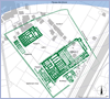
Tell el-Dabca
|
|
| |
| |
(8km north of Markaz Faqus, eastern Delta, 30°
47’ N, 31° 50’ E) can be identified
now certainty with Avaris, capital
of the Hyksos (c. 1640-1530 BC) and
with the southern part of Piramesse, the Delta residence
of Ramesses II and his successors. In the 18th Dynasty
the site can most probably be identified with Peru-nefer,
the major naval and military stronghold of the Tuthmosides.
Most probably this place was also identical with the
biblical town Raamses/Ramesse from the time of the Ramessides.
The easternmost branch of the Nile passed once west
of the site.
History of the Excavation
Excavations there started 1885 by E. Naville.
1941-42 Labib Habachi worked there for the Egyptian
Antiquities Service and suggested an identification
with Avaris.
1951-1954 Shehata Adam excavated partly the 12th Dynasty-site
of cEzbet Rushdi.
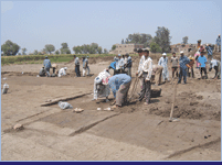
1966-69 and from 1975 onwards the site is under survey and excavation with
more than 45 field- and study campaigns by the Austrian Archaeological
Institute in Cairo (1966-2009 director Manfred Bietak, since 2009 Irene
Forstner-Müller).
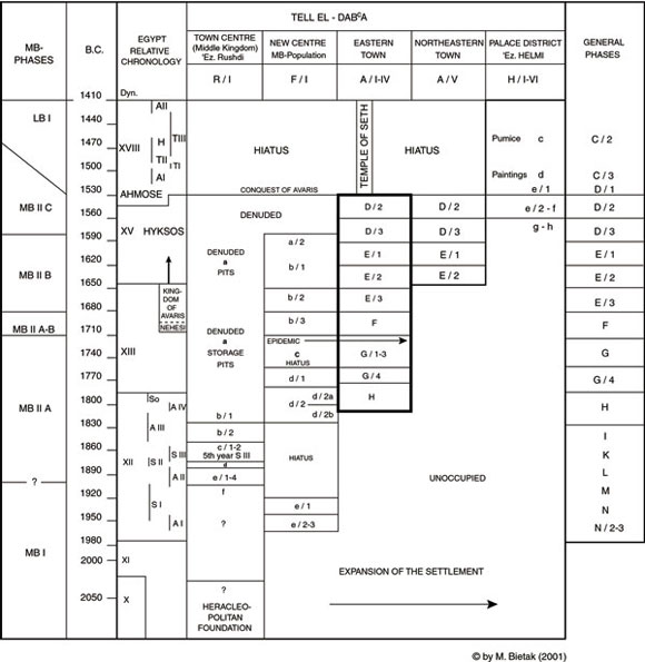
History of the site
The history of this site started at the beginning of
12th Dynasty under Amenemhet I (c. 1963-1934 BC) with
a planned settlement (str. M-N). |
|
| |
 |
|
| |
| |
Probably already in the Heracleopolitan
period existed an estate of a king Khety with the name
Hw.t R3w3.ty Hty. Soon afterwards another settlement
spread at the southeastern bank of the Pelusiac Nile
Branch at cEzbet Rushdi es-sagira (str. I-L)
(>>cEzbet Rushdi).
A memorial temple for Amenemhet I, the founder of the
12th Dynasty was constructed in the year 5 by Senwosret
III (c. 1872-1853 BC) (str. K-H). This temple was abandoned
already in the second half of the 18th century BC during
the time of the 13th Dynasty.
From the late 12th Dynasty onwards a community of Asiatics
(carriers of the Syro-palestinian Middle Bronze Age
culture IIA) settled there, which led to a considerable
enlargement of the town (str. H) (>>stratum
H).
The majority of the settlers seemed to serve under the
Egyptian Crown to judge from the offerings in the tombs.
Probably they were employed as soldiers, sailors, shipbuilders
and craftsmen. Their tombs can be found in the midst
of the settlement.
During the time of the 13th Dynasty a palatial quarter
for officials was constructed (str. G/4). It seems that
their function was to supervise trade and expeditions
abroad. They were in Egyptian services but were of Asiatic
origin. A cemetery with domed chapels as superstructures
belonging to those officials was found attached to the
building (>>stratum
G/4).
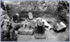
Statues of queen Nofru-Sobek and king Hornedjheryotef
of the late 12th and early 13th Dynasty, found by Labib
Habachi, were probably only transported to this site
in later times together with numerous other royal statuary
(pic.
1).
The settlement increased steadily. In the second half
of the 18th century BC (str. G) a strong influx of syro-palestinian
MB-elements is noticable. |
|
| |
|
|
| |
|
|
| |
With str. F and E/3 a sacred precinct
was constructed in the Eastern town (>>area
A/II).
It consisted of two temples of Near Eastern type and
mortuary chapels of Egyptian typology with adjoining
cemeteries. In front of the main temple, remains of
oak tree pits were identified. Probably the cult can
be associated with the Canaanite godess Ashera in syncretism
with the Egyptian goddess Hathor who not only was established
in the Near East too but also had an association with
mortuary cult.
As dynastic god the Egyptian storm god Seth was introduced.
There is every reason to believe that he is at this
site only the Egyptian version of the Syrian storm god
Hadad/Baal-Zaphon because a seal cylinder with a representation
of this Canaanite god was found already in the palace
of the early 13th Dynasty (str. G/4). As the seal was
locally made, the conclusion can be drawn that the cult
of this god was already established in the Eastern Delta
(>>stratum
G/4).
Of special interest is the development of settlement.
From str. F onwards a tendency towards a social differentiation
can be observed. Bigger houses are surrounded by smaller
houses on the same plots while before in str. G an egalitarian
pattern prevailed. With the beginning of the Hyksos
Period (str. E/2-1) the town expanded considerably to
250 hectar. This goes hand in hand with a gradual internal
intensification in settling. One gets the impression
that Egyptianised Asiatics who settled previously at
other areas of Egypt concentrated now in the Eastern
Delta and contributed to the built up of a "homeland"
for the carriers of the Hyksos rule in Egypt.
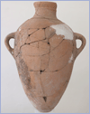
The evaluation of the ceramical material shows that
most of the imports were in the Hyksos Period amphorae
from Syria/Palestine, which contained originally wine
or olive oil (pic.
2). |
|
| |
|
|
| |
| |
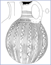
Imports of Cypriot pottery increased considerably
after c. 1650 and had a remarkable floruit in some parts
of the town towards the end of the Hyksos period
(pic. 3).
An increasingly isolationistic tendency can be seen in
the internal trade. Towards the end of the Hyksos Period
(str. D/2) at the western edge of Avaris, along the eastern
bank of the Pelusiac branch, a huge citadel was constructed
on hitherto uninhabited land (>>citadel).
|
| |
|
|
| |
| |
After the conquest of Avaris by Ahmose
c. 1530 BC the major part of the town was abandoned. The
citadel, however, was destroyed and enormous storage facilities
set up, among them numerous silos. On top of those remains
traces of a camp with bonfires a, ovens and postholes
of tents were encountered. Bodies probably of soldiers
were buried without any offerings in pits. Also bodies
of several horses were found in this stratum.
On top of the camps and soldier graves a new palatial
compound of the 18th Dynasty was constructed mainly of
brick material from the Hyksos citadel. It consisted of
three palaces, all of them constructed on elevated platforms
(pic.
4).
At least two palaces (Palace F and G).had been decorated
by Minoan wall paintings (>>palatial
compound ). |
|
| |
|
|
| |
| |
The palatial precinct which covered an
area of 5.5 hectar (13 Feddan) was surrounded by an enclosure
wall with an entrance pylon in the north. Together with
the town in the south and the bay at the river in the
north it can most probably be identified with Peru-nefer,
the major Egyptian naval and military stronghold. The
palace which dates precisely from Tuthmosis III and Amenophis
II, the time when Peru-nefer was active, the presence
of Nubian soldiers as evidenced by Kerma pottery and Kerma
arrow tips as well as workshops producing arrows and slingshots
proves the presence of military units.
Later the ruins of the Tuthmoside Period were covered
by a fortress of Horemheb, a time when Peru-nefer was
in need for building up military measures against the
new military superpower, the Hittites.
In the time of the 21st and 22nd Dynasties and afterwards
TD as southern part of Piramesse served as a quarry to
procure building material, especially stone blocks and
monumental statues for the new residences at Tanis, Bubastis,
Leontopolis (Tell el-Muqdam) and elsewhere. Together with
the monuments also cults of Piramesse were to some extent
transferred to the new sites.
It is not surprising therefore that in the time of the
30th Dynasty secondary cults of the gods of Ramses II
appeared in Tanis and Bubastis independently. This explains
why already in antiquity the town of Raamses/Ramesse was
located at Tanis (Ps. 78:12, 48) and to the East of Bubastis
in the Wadi Tumilat (Septuagint version of Gn. 46:28-29).
Without knowing the original position of Avaris, Piramesse,
the identity of thos two towns and also their identity
with the biblical town of Raamses/Ramesse was kept in
memory till the Manethonian tradition according to Josephus
(C. Ap., I.26-31, §§ 237-287). |
|
| |
 |
| |
Bibliography: |
|
Bietak, M.
|
| 1968 |
|
Vorläufiger Bericht über die erste und
zweite Kampagne der österreichischen Ausgrabungen
auf Tell ed-Dabca im Ostdelta Ägyptens
(1966/1967), MDIK 23,
79-114. |
|
| 1970 |
|
Vorläufiger Bericht über die dritte
Kampagne der österreichischen Ausgrabungen
auf Tell ed-Dab‘a, MDIK 26, 15-41. |
|
| 1989 |
|
Servant Burials in the Middle Bronze Age Culture
of the Eastern Nile Delta, EI 20, 30-43. |
|
| 1991 |
|
Unter Mitarbeit von C. Mlinar und A. Schwab, Tell
el- Dabca V, Ein Friedhofsbezirk der
Mittleren Bronzezeitkultur mit Totentempel und Siedlungsschichten,
UZK VIII. Österreichische Akademie der Wissenschaften,
Denkschriften der Gesamtakademie IX, Wien |
|
| 1994a |
|
Kleine ägyptische Tempel und Wohnhäuser
des späten Mittleren Reiches. Zur Genese eines
beliebten Raumkonzeptes von Tempeln des Neuen Reiches,
in: C. Berger, G. Clerc und N. Grimal, Hommages
à Jean Leclant. IFAO, Kairo, 413-435. |
|
| 1994b |
|
"Götterwohnung und Menschenwohnung",
Die Entstehung eines Tempeltyps des Mittleren Reiches
aus der zeitgenössischen Wohnarchitektur, HÄB
37, 13-22. |
|
| 2002 |
|
Temple or 'Beth Marzeah' ? in Symbiosis, Symbolism
and the Power of the Past: Canaan, Ancient Israel
and their Neighbors, From the Late Bronze Age through
Roman Palestine. The W.F. Albright Institute of
Archaeological Research and the American Schools
of Oriental Research Centennial Symposium, Israel
Museum, Jerusalem, May 29-31, 2000, eds. W.G. Dever
and S. Gitin. Winona Lake, Ind. 2002 |
|
Boessneck, J.
|
| 1976 |
|
Tell el- Dabca III. Die Tierknochenfunde
1966-1969, UZK III. Österreichische Akademie
der Wissenschaften, Denkschriften der Gesamtakademie
V, Wien |
|
|
| |
|
|