|
| |
| |
The orthogonal planned settlement
of the early Middle Kingdo (F/I, stratum e)
by Ernst Czerny |
|
| |
| |
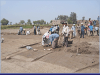
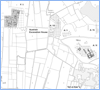
In 1979 the excavation activities within the huge site
of Tell el-Dabca moved towards an area which
was designated as "F/I", just 500 m to the west
of the tell itself (pic.
1). |
|
| |
|
|
| |
The most prominent feature of the manifold archaeological
remains of that area is undoubtedly the so-called Palace,
a large residential structure of the early 13th Dynasty
(see
the contribution of R. Schiestl, F/I, str. d/1).
However, below this monumental building, earlier strata
were preserved. The oldest one of these, designated as
F/I, str. e, was directly situated on the original surface
of the "Gezirah", a feature of the natural landscape.
It contained the remains of a mud-brick settlement, which
in the course of its investigation could be dated to the
beginning of the Middle Kingdom, most likely into the
epoch of king Amenemhat I., the founder of the 12th dynasty
(1973–1944 BC according to K. Kitchen’s chronology)
(pic. 2). |
|
| |
|
|
| |
| |
Therefore, these ruins can be considered
as the oldest architectural remains hitherto discovered
at Tell el-Dabca. Clearly, the whole structure
was the result of state-run internal colonisation, with
the aim of establishing royal administration and power
at the eastern border of the Egyptian kingdom. Literary
sources, such as, e.g., the "Instructions for king
Merikare" mention exactly this kind of internal colonisation
and it is well-known, also from literary sources, that
king Amenmhat I. was much concerned with the eastern border.
Nothing of the fortifications which this king is known
to have erected along the eastern edge of the Delta has
been found by archaeological investigations, but it is
highly probable that the Tell el-Dabca settlement
is in some way connected with this important defence project
which must have been undertaken in its close neighbourhood.
The settlement was excavated only to a small extent. Parts
of an enclosure wall were exposed along the north edge,
but neither a corner of this wall nor an entrance have
been found. Consequently, the original size of the structure
remains unknown. Being only c. 160 cm (41/2 bricks) thick,
the enclosure wall did not serve for defence. The number
of 342 documented houses is only a part of the original
settlement, which must have stretched farther west and
south, possibly also east.
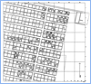
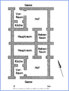
All excavated houses were originally of the same size
and shape and were arranged in blocks of single rows along
the enclosure and double rows farther south. The blocks
of the eastern row contained 12 houses each and those
on the western row 24 (+x?) houses, respectively. The
2 northernmost blocks near the enclosure had 6 and 12
houses only. A large building, whose purpose remains unclear,
lay in the north-east corner of the area, south of which
nothing was found but a large open space.
Although each of the houses was divided into 4 rooms facing
two sides of a courtyard, they were among the smallest
houses ever excavated in Egypt. The internal surface was
only 27 m2 each, so that the settlement, when fully inhabited,
must have been densely crowded (pic.
3, pic. 4). |
|
| |
|
|
| |
|
|
| |
However, this seems only to have been
the case for a short time at the beginning. After a while,
the inhabitants began to alter their houses, often connecting
two or even more of them to a larger unit.
Later, the whole structure was given up and completely
new houses were built above the remains of the original
ones. These were much larger and not uniform, but individually
shaped, indicating that the state-planned settlement had
been replaced by privately planned dwellings, large enough
to use them as farmer’s houses or artisan’s
work-shops. They followed, however, the ancient streets
and respected the borders of the previous blocks. These
houses of the uppermost strata of the settlement are badly
destroyed by the more recent building activities of late
Middle Kingdom.
The necropolis of the inhabitants could not be discovered.
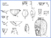
The finds within the settlement were almost exclusively
pottery-sherds, silices and animal bones. No objects of
any value were left behind by the last inhabitants, and
any organic material has decayed in the humid ground of
the delta (pic.
5, pic.
6, pic.
7). |
|
| |
|
|
| |
| |
A thorough study of the pottery remains
was therefore the most promising way to establish the
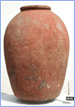
dating and cultural context of the settlement. Most vessels
were plates, bowls, (some with carination), bottles, pots,
cooking pots, pithoi, bread moulds and spinning bowls.
58% of the rim sherds were of Nile B fabric, 29% of Nile
C fabric, less than 1% of Nile E and Marl A fabrics and
12% of Marl C. As far as the different types could be
reconstructed, the pottery had its closest parallels in
the one of the west-delta settlement of Abu Ghalib, notwithstanding
many parallels with the pottery from Sedment and, to a
lesser extent, from sites such as Harageh, Gurob, Beni
Hassan, Denderah, Qau, Rifeh, Tarif, and Lisht. Sherds
of non-Egyptian origin were extremely rare. They came
from very rough hand-made vessels probably from the Sinai
or the Negev and were considered as a proof that contact
(and trade?) with Bedouins had occurred.
The Egyptian pottery of most of the sites mentioned as
parallels has been re-evaluated by S. Seidlmayer in 1990,
who was able to create a typological system and to date
it convincingly. Fitting the Tell el-Dabca pottery
into this system, the dating of the settlement could be
established as the early Middle Kingdom, probably into
the reign of King Amenemhat I. Additional finds, such
as a few scarabs and fragments of Alabaster-vessels, confirmed
this view.
The silices proved that the inhabitants of the settlement
worked as farmers, although this was probably not their
primary and main occupation. Most of the flint implements
were sickle-stones, very worn and showing the so-called
sickle-glance. A. Tillmann demonstrated that the source
of the silex was the Wadi el-Sheik in Middle Egypt, and
not, as became the rule during the Middle Kingdom, the
Theban area in the south of Egypt.
Remains of animals and plants allowed the reconstruction
of the flora and fauna supplying this settlement.
Altogether, the results of the excavation of the settlement
of Tell el-Dabca, F/I, str. e shed light on the
hard and, until now, only scarcely documented conditions
of everyday life of an Egyptian town of the early Middle
Kingdom, far from the splendour of temples and the royal
court. |
| |
 |
| |
| |
Bibliography:
|
Czerny E.
|
| Tell el-Dabca IX. Eine Plansiedlung
des frühen Mittleren Reiches. UZK 15, ÖAW,
Vienna 1999 |
| |
Boessneck J. und Von den Driesch A.
|
| Tierknochenfunde aus der frühen 12. Dynastie
vom Tell el-Dabca im Nildelta, in E. Czerny,
op.cit. |
| |
Tanheiser U.
|
Untersuchungen zur ägyptischen Landwirtschaft
in dynastischer Zeit an Hand von Pflanzenresten
aus Tell el-Dabca.
PHD thesis Vienna
1987. |
| |
Tillmann A.
|
| Steinzeitkultur in der Hochkultur anhand des Materials
aus Tell el-Dabca und Qantir, forthcoming. |
| |
Bietak M. und Eigner D.
|
| Tell el-Dabca XIV, Ein Palastbezirk
des späten Mittleren Reiches und andere Siedlungsschichten.
Pläne und Profile, Vienna, forthcoming. |
|
| Tell el-Dabca, Ein Palastbezirk des
späten Mittleren Reiches und andere Siedlungsschichten,
Stratigraphie, archäologischer Befund und Architektur.
In preparation. |
| |
for parallels see also:
|
Seidlmayer S.J.
|
| Gräberfelder aus dem Übergang vom Alten
zum Mittleren Reich, SAGA 1, Heidelberg 1990 |
| |
Bagh T.
|
| Abu Ghalib, an Early Middle Kingdom Town in the
Western Nile Delta: Renewed Work on Material Excavated
in the 1930s, MDAIK 58(2002), 29– 61. |
|
|
| |
|
|